National Park
The nature of Bonaire, Saba and St. Eustatius
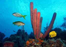 The topography of Bonaire is fairly common in the southern Caribbean. A low (up to 241 m) island represents the top of the underwater elevations of the continental shelf that frames the South American continent. The low coast of Bonaire to the north slowly rises, gradually moving into a hilly area surrounded by lagoons and bays of the Washington-Slagbay National Park. Almost the entire surface of the island is overgrown with lush tropical vegetation (mostly secondary forests), interrupted only by settlements, agricultural land and long beaches.
Saba and Sint Eustatius are as typical in their origin and natural and climatic conditions for the Windward Islands as the “ABC Islands” for the Leeward. Formed by the peaks of ancient underwater volcanoes, they for the most part have a rounded shape and a fairly elevated relief. The rounded Saba is the top of an ancient volcano, the last eruption of which occurred, Continue reading
